
If we keep burning fossil fuels indefinitely, global warming will eventually melt all the ice at the poles and on mountaintops, raising sea level by 216 feet. Explore what the world’s new coastlines would look like.
The maps here show the world as it is now, with only one difference: All the ice on land has melted and drained into the sea, raising it 216 feet and creating new shorelines for our continents and inland seas.
There are more than five million cubic miles of ice on Earth, and some scientists say it would take more than 5,000 years to melt it all. If we continue adding carbon to the atmosphere, we’ll very likely create an ice-free planet, with an average temperature of perhaps 80 degrees Fahrenheit instead of the current 58.

North America
The entire Atlantic seaboard would vanish, along with Florida and the Gulf Coast. In California, San Francisco’s hills would become a cluster of islands and the Central Valley a giant bay. The Gulf of California would stretch north past the latitude of San Diego—not that there’d be a San Diego.
South America
The Amazon Basin in the north and the Paraguay River Basin in the south would become Atlantic inlets, wiping out Buenos Aires, coastal Uruguay, and most of Paraguay. Mountainous stretches would survive along the Caribbean coast and in Central America.
Africa
Compared with other continents, Africa would lose less of its land to the ultimate sea-level catastrophe, but Earth’s rising heat might make much of it uninhabitable. In Egypt, Alexandria and Cairo will be swamped by the intruding Mediterranean.
Europe
London? A memory. Venice? Reclaimed by the Adriatic Sea. Thousands of years from now, in this catastrophic scenario, the Netherlands will have long since surrendered to the sea, and most of Denmark will be gone too. Meanwhile, the Mediterranean’s expanding waters will also have swelled the Black and Caspian Seas.
Asia
Land now inhabited by 600 million Chinese would flood, as would all of Bangladesh, population 160 million, and much of coastal India. The inundation of the Mekong Delta would leave Cambodia’s Cardamom Mountains stranded as an island.
Australia
Predominantly desert, the continent would gain a new inland sea—but it would lose much of the narrow coastal strip where four out of five Australians now live.
Antarctica
East Antarctica: The East Antarctica ice sheet is so large—it contains four-fifths of all the ice on Earth—that it might seem unmeltable. It survived earlier warm periods intact. Lately it seems to be thickening slightly—because of global warming. The warmer atmosphere holds more water vapor, which falls as snow on East Antarctica. But even this behemoth is unlikely to survive a return to an Eocene Climate.
West Antarctica: Like the Greenland ice sheet, the West Antarctic one was apparently much smaller during earlier warm periods. It’s vulnerable because most of it sits on bedrock that’s below sea level.The warming ocean is melting the floating ice sheet itself from below, causing it to collapse. Since 1992 it has averaged a net loss of 65 million metric tons of ice a year.

National Geographic made precise maps on how Earth would look in the case all the planet’s ice melted.
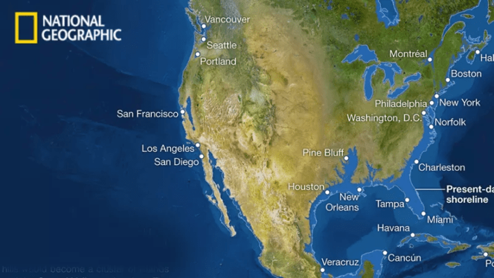
New York, San Francisco, New Orleans, London and other cool cities would be completely gone, the entire state of Florida would disappear
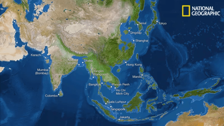
Take a look at the entire Chinese and Indian coastlines, the most densely populated areas in the world.

The situation in Europe would be equally catastrophic.
The initial massive economic loss, a coastline change like this would provoke unprecedented population migrations across continents, which in turn would generate damage of apocalyptical proportions—pestilence, war, famine, and death would ensue across the globe.
Head to National Geographic for more of these fascinating maps
CREDIT: JASON TREAT, MATTHEW TWOMBLY, WEB BARR, MAGGIE SMITH, NGM STAFF. ART: KEES VEENENBOS.
SOURCES: PHILIPPE HUYBRECHTS, VRIJE UNIVERSITEIT BRUSSEL; RICHARD S. WILLIAMS, JR., WOODS HOLE RESEARCH CENTER; JAMES C. ZACHOS, UNIVERSITY OF CALIFORNIA, SANTA CRUZ; USGS; NOAA, ETOPO1 BEDROCK, 1 ARC-MINUTE GLOBAL RELIEF MODEL COPYRIGHT © SEPTEMBER 2013 NATIONAL GEOGRAPHIC


Track sharks, whales, turtles, seals, dolphins, alligators
The OCEARCH an collaborative, inclusive and open-sourced project to geared to helping scientists collect previously unattainable data on animal movements from deep in the world’s oceans.
